 |
|||
|
Page Title:
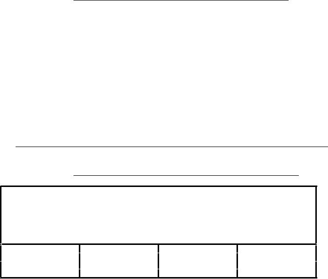
Table 91. Land cover point feature table (LCPOINT.PFT). |
|
||
| ||||||||||
|
|  MIL-D-89009
APPENDIX
TABLE 90. Land cover area feature table (LCAREA.AFT) -
Continued.
1
Indicates that the feature may only be represented by text primitive
in certain cases.
2
If the feature is represented as a point, then it is stored as a text
primitive only. If point is present, feature will be captured in
CLPOINT.
3
When represented by a point feature, the ONC code is (902.1).
4
When represented by a point feature, the ONC code is (902.2).
5
All ONC feature with the sand symbol are stored with the type
attribute value or unconsolidated materials feature. Features with this
symbology are not bounded by lines on the ONC. In the ONC, for example,
sand may overlap with ice to form a glacial moraine symbol.
TABLE 91. Land cover point feature table (LCPOINT.PFT).
{Header length};\
Land Cover points;LCPOINT.DOC;\
ID=
I,1,P,Row Identifier,-,-,:\
LCPTTYPE=I,1,N,Type of Land Cover Points,INT.VDT,-,:\
TILE_ID= S,1,F,Tile Reference Identifier,-,LCPOINT.PTI,:\
END_ID= I,1,F,Point Primitive Foreign Key,-,-,:;
1
3
169
1
2
2
301
2
:
:
:
:
n
n
n
n
LCPTTYPE
Features too small for area representation are captured as points and stored
in the LCPOINT.PFT with the following LCPTTYPE attribute values.
ONC Codes
1
=
Mines
902.1
Quarries1,2 /Strip mines1,2 /Mine dumps1,2
2
=
902.2
Blasting areas
Miscellaneous land features1
3
=
414.5
Notes
1 Annotation will distinguish point types.
2
Can be in point or polygon coverage depending on feature type.
120
|
|
Privacy Statement - Press Release - Copyright Information. - Contact Us |
