 |
|||
|
|
|||
| ||||||||||
|
| 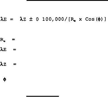 MIL-D-70789A (AR)
6.6.1.4 Extended
zone
boundaries.
The boundaries for extended UTM zones are:
Where:
Ellipsoidal Radius of the Earth (meters)
Geographic Longitude of Extended Zone Boundary
(radians)
Geographic Longitude of the Normal Zone Boundary
(radians)
= Geographic Latitude of the DRU (radians)
A spheroid code number, either in
6.6.1.5 Spheroids.
memory or input via the ACCEPT POSITION command during Normal
Align; indicates which spheroid parameters are to be used by the
When output is
DRU to compute coordinates and grid convergence.
The parameters
requested, the DRU repeats the last value input.
of the following reference spheroids shall be selected by
entering the corresponding code number:
INVERSE
SEMI-MAJOR AXIS
FLATTENING
(Meters)
SPHEROID .
CODE NO.
299.3249646
BNG (Airy)
6377563.396
0
294.9786982
1
6378206.4
Clarke 1866
International
2
297.0
(Hayford 1909)
6378388
293.465
6378249.145
3
Clarke 1880
300.8017
6377276.345
4
Everest 1830
6377397.155
299.1528128
Bessel 1841
5
298.257223563
6378137
6
Spare
298.257223563
7
6378137
Spare
298.247167427
6378160
8
GRS 1967
298.257223563
6378137
9
GRS 80/WGS 84
299.3249646
Airy
6377563.396
10
299.3249646
6377340.189
11
Modified Airy
300.8017
6377304.063
12
Modified Everest
298.26
13
WGS 1972
6378135
297.0
6378270
Hough
14
Indicates no change to presently selected spheroid.
15
When spheroid code No. O is selected, the DRU will operate in the
129
|
|
Privacy Statement - Press Release - Copyright Information. - Contact Us |
