 |
|||
|
Page Title:
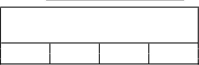
Table 83. Hypsography area feature table (HYAREA.AFT). |
|
||
| ||||||||||
|
|  MIL-D-89009
APPENDIX
TABLE 83. Hypsography area feature table (HYAREA.AFT).
{Header length};\
Hyposgraphic Areas;HYAREA.DOC;\
ID=
I,1,P,Row Identifier,-,-,:\
HYPYTYPE=I,1,N,Elevation zone,INT.VDT,-,:\
TILE_ID= S,1,F,Tile Reference Identifier,-,HYAREA.ATI,:\
FAC_ID= I,1,F,Face Primitive Foreign Key,-,-,:;
1
4
176
1
2
3
201
2
:
:
:
:
n
n
n
n
HYPYTYPE
ONC Codes
1 = Below sea level1
2 = 0 to 1,000 feet above sea level2
3 = 1,000 - 3,000 ( 1,000)3
4 = 3,000 - 7,000 ( 1,000)3
5 = 7,000 - 11,000 ( 1,000)3
6 = 11,000 and above
7 = Uncontoured
408.2
or unsurveyed
408.3
8 = Area does not have a 1000-foot
interval (exists only on JNC)
9 = None
Notes
The elevation coverage does not contain the coastal shoreline.
This
feature is stored in the Political/oceans coverage.
Where required, connectors have been added to contours to create
continuous elevation zones.
1
This condition exists in Death Valley.
2
Areal features include complete contours at 1000-foot intervals. The
hypsography area feature table does not include the coastal shoreline as
the 0 contour interval.
3
If a standard 1000-foot contour cannot be closed, however, and the
contour interval that is either 1000 feet lower or higher in elevation
is present, the higher elevation value is the preferred value for
coding.
The area features of HYAREA.AFT are organized to provide a useful
vertical zonation. Useful signifies a few carefully selected zones
rather than a more detailed classification for every 1000 feet. The
criteria employed in the selection of the vertical zones were as
follows:
Zones coincide with the cartographic layer tinting decisions made
on many ONC sheets. For example, on ONC sheet G-18, there are
layer tints at 7,000 and 11,000 feet. Other sheets have employed
other zone decisions.
109
|
|
Privacy Statement - Press Release - Copyright Information. - Contact Us |
